

Reviewed and updated 2 September 2026.
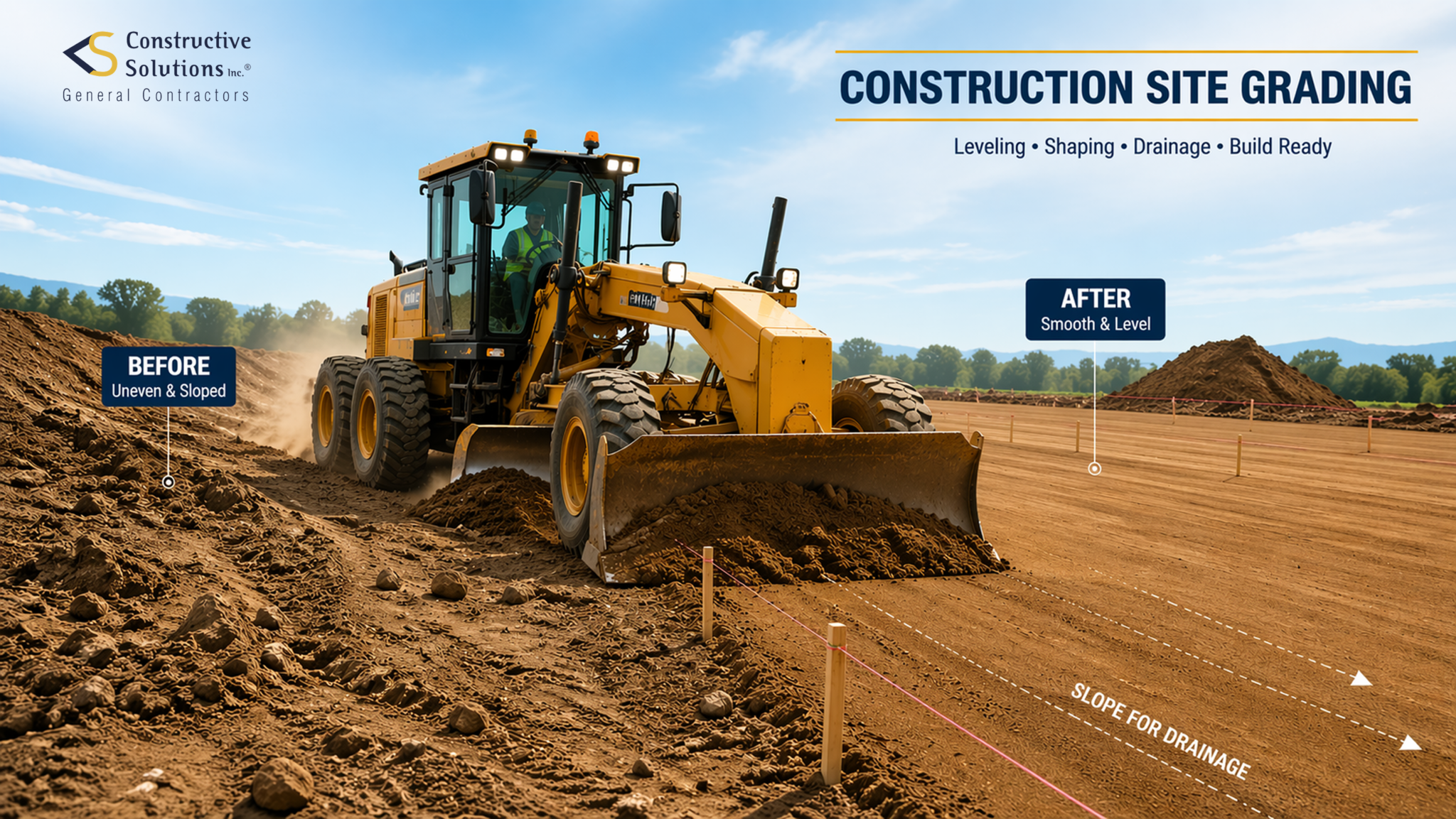
Construction grading shapes the ground so a commercial site can support buildings, paving, utilities, accessible routes, landscaping and a planned drainage system. It is not simply making dirt look level. A grading plan coordinates elevations, slopes, cut and fill, drainage features and limits of disturbance with the rest of the project documents.
This guide is written for commercial property owners, developers, tenants and project teams who need to understand what a grading plan communicates, what decisions affect cost and schedule, and what to verify before earthwork begins. It is educational, not a substitute for project-specific civil, geotechnical, surveying, environmental or legal advice.
What Is Grading in Construction?
Grading is the process of adjusting a site’s ground surface to the planned shape and elevation. Depending on the project, the work may include stripping unsuitable surface material, excavating high areas, placing and compacting approved fill, forming a building pad, creating swales, preparing paved areas and coordinating stormwater features.
The finished surface may appear simple, but the design behind it connects many systems. The building entrance must relate to exterior walks and accessible routes. Pavement must drain without directing water toward the building. Utility structures must meet the surrounding grade. Retaining elements, landscape areas and property boundaries constrain where elevation changes can occur. A change in one area can affect several others.
For owners, the useful question is not “Is the site flat?” It is: “Does the proposed grading create a buildable, drainable and coordinated site that matches the approved documents?”
Excavation vs. Leveling vs. Grading: What Is the Difference?
| Term | What it generally means | What an owner should verify |
|---|---|---|
| Excavation | Removing soil or rock for foundations, utilities, lower elevations or other planned work. | Limits, depth, support and protection requirements, haul-off assumptions, unsuitable material and coordination with existing utilities. |
| Leveling | A general description for making a localized surface more even. It is not a complete site-drainage strategy. | Which elevation controls the work and whether the surface must actually slope for drainage or accessibility. |
| Grading | Shaping a broader site to proposed elevations and drainage patterns through cut, fill and surface refinement. | Approved plan, benchmark, contours, spot elevations, slopes, drainage path, soil criteria and inspection or testing requirements. |
Excavation can be part of grading, and grading can include areas that are intentionally not level. The terms overlap in conversation, so bid packages and scopes should define the actual work rather than rely on a label.
Why Grading Matters on a Commercial Project
Grading affects far more than the earthwork line item. It establishes the physical relationship among the building, parking, walks, loading areas, landscape zones, utilities and stormwater system. Good coordination can expose conflicts while they are still drawings rather than field conditions.
- Drainage: proposed grades help direct runoff toward the collection, conveyance or treatment features shown by the design team.
- Building interface: pad elevations and exterior grades affect foundations, entrances, waterproofing interfaces and adjacent paving.
- Accessibility: exterior accessible routes, parking and transitions must be coordinated with the applicable design requirements. The project documents control the exact values.
- Utilities: rims, inverts, cover and service routes need to work with proposed surface elevations.
- Constructability: cut/fill balance, site access, soil handling, temporary drainage and sequencing influence logistics, cost and time.
- Environmental controls: disturbed soil and construction runoff may trigger erosion, sediment and stormwater obligations.
California’s Construction General Permit applies to qualifying construction activity that disturbs one or more acres, and also to certain smaller sites that are part of a larger common plan of development. The State Water Resources Control Board is the appropriate source for current statewide program information; local and project-specific requirements may add other obligations.
Construction Grading Types and Uses
Rough grading
Rough grading establishes the general site form. It may include mass excavation, embankment, building-pad preparation and broad drainage shapes. Surfaces remain suitable for later work rather than finished appearance.
Fine grading and final grading
Fine grading refines elevations and tolerances before slabs, aggregate base, paving, walks or other improvements. Final grading completes exposed landscape or drainage surfaces and resolves transitions around installed work. Project teams sometimes use these terms differently, so the scope should state what surfaces and tolerances are included.
Finish grading around improvements
After utilities, curbs, structures or retaining work are installed, localized grading ties those components into the surrounding site. This is where incomplete coordination often becomes visible: a utility rim is high, an inlet is not at the intended low point, or an entrance transition no longer matches adjacent paving.
What Is a Site Grading Plan?
A site grading plan is a drawing—or coordinated set of drawings—that shows existing and proposed ground conditions. It may include contours, spot elevations, slopes, drainage arrows, building finish-floor elevations, swales, inlets, walls, property and grading limits, utilities, erosion controls, sections and construction notes.
The sheet is not meant to stand alone. Owners should read it with the civil details, survey information, geotechnical report, architectural site plan, landscape and utility drawings, specifications and permit comments. The title block and revision history help confirm that everyone is reviewing the same issue of the documents.

How to Read Grading Plans: A Nine-Step Owner Review
- Start with the title block and revision record. Confirm the project, sheet number, issue date, purpose of issue and latest revision. A well-read obsolete sheet is still the wrong sheet.
- Read the legend, scale and north arrow. Line types and abbreviations are not universal. Verify them against the specific drawing before interpreting a contour or boundary.
- Find the benchmark and vertical datum. Elevations depend on a defined reference. The survey and civil documents should agree on the control used in the field.
- Separate existing from proposed contours. Contours connect points of equal elevation. Their spacing suggests relative steepness, but the drawing scale and contour interval matter. Never assume a line type without the legend.
- Locate spot elevations, finish-floor elevations and grade breaks. These point values clarify important surfaces and transitions that contours alone may not communicate.
- Trace the intended drainage path. Follow arrows, swales, curbs, inlets and other features from higher areas to the planned collection or discharge point. Ask what happens at thresholds, low points and property edges.
- Identify cut, fill, walls and disturbance limits. Compare proposed grades with existing conditions. Note where earth must be removed, where approved fill is placed and where elevation change is constrained.
- Coordinate utilities, easements, erosion controls and details. Surface grades must work with utility elevations and access. Construction-phase controls may change as the work progresses.
- Record conflicts as questions. Owners should not redesign the sheet in the field. Route discrepancies through the project’s RFI and document-control process for review by the appropriate professional.
Common Grading-Plan Symbols and What They Tell You
| Item | Typical purpose | Review question |
|---|---|---|
| Existing contour | Represents the surveyed pre-project surface. | Is the survey current enough for the proposed work? |
| Proposed contour | Represents the designed surface after grading. | Where do contours tighten, bend or meet improvements? |
| Spot elevation | Provides a precise design elevation at a point. | Does it coordinate with entrances, paving, rims and adjacent grades? |
| Finish-floor elevation | Sets a key building elevation reference. | How do exterior routes and drainage relate to it? |
| Slope or drainage arrow | Shows direction of fall; a value may be shown where designed. | Where does the water go next? |
| Swale | Forms a shallow channel to convey or manage runoff. | Is it coordinated with landscape, access and the receiving feature? |
| Storm drain inlet | Collects surface runoff for the designed system. | Is it at the intended low point and coordinated with underground work? |
| Limits of grading/disturbance | Defines the planned work boundary. | Does access, stockpiling or temporary work extend beyond it? |
Cut, Fill and Drainage as One Coordinated System
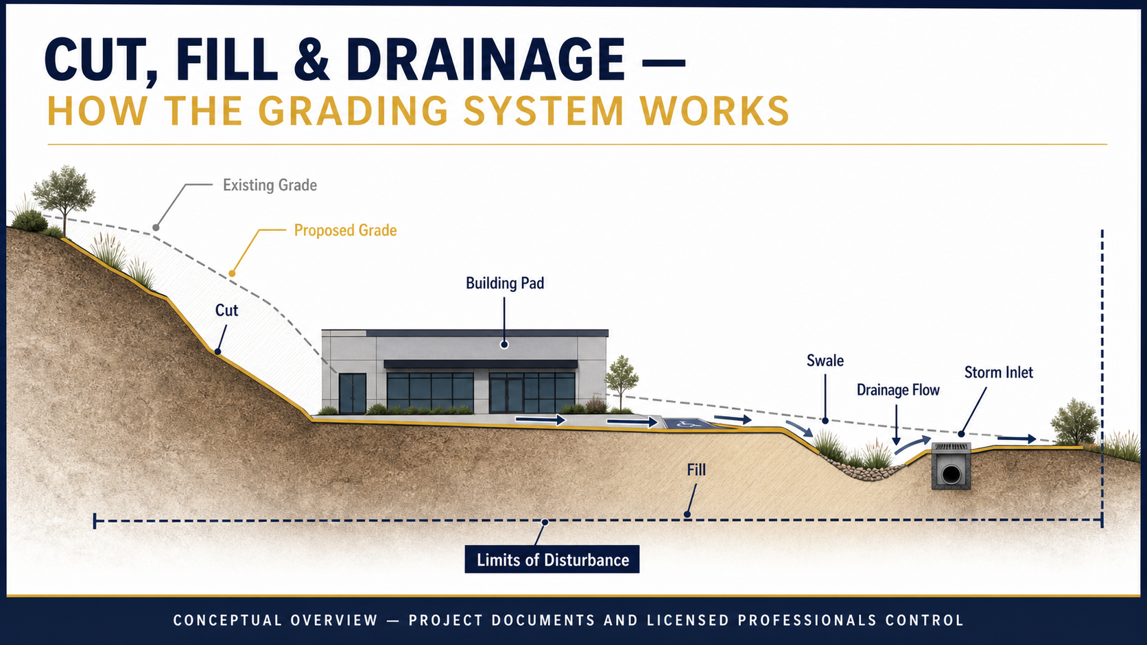
Cut removes material to reach a lower proposed grade. Fill raises an area with material that meets the project requirements and is placed and compacted as specified. A project may use excavated material as fill only when the design documents and appropriate professionals accept its characteristics and intended use.
Cut and fill decisions affect trucking, stockpiles, dust and track-out control, equipment access, temporary stabilization, utility sequencing and the exposure of unexpected subsurface conditions. A simple volume estimate does not answer whether the material is suitable, whether it can be processed and placed efficiently, or whether site constraints permit balancing it on site.
Who Is Responsible for What?
| Participant | Typical grading-related role |
|---|---|
| Owner/developer | Defines project objectives, authorizes investigations and design, makes risk decisions and maintains clear contracts and decision paths. |
| Civil engineer | Develops the site-grading and drainage design within the professional’s contracted scope and responds to design questions. |
| Geotechnical professional | Evaluates subsurface conditions and provides project-specific recommendations; may observe and test work as contracted. |
| Land surveyor | Establishes or verifies survey control and performs layout or record survey services within the contracted scope. |
| General contractor or construction manager | Coordinates drawings, trades, logistics, sequence, RFIs, inspections and documentation under the construction agreement. |
| Grading/earthwork contractor | Performs the contracted earthwork using the approved documents and applicable licensing and safety requirements. |
| Authority having jurisdiction | Reviews permit documents and performs the reviews or inspections required by its process; it does not replace the design team’s responsibility. |
Roles vary with the delivery method and contracts. In California, the Contractors State License Board describes the C-12 Earthwork and Paving classification; owners should verify the classification and status appropriate to the actual contracted scope rather than infer capability from a company name.
Step-by-Step Construction Grading Process
- Existing-condition due diligence: survey, subsurface information, utility research, access constraints and environmental conditions establish the basis for design and estimating.
- Design coordination: civil, architectural, structural, landscape and utility information is compared so elevations and interfaces agree.
- Permit and preconstruction review: the team tracks agency comments, issue status, long-lead decisions, testing responsibilities, temporary controls and the intended sequence.
- Layout and controls: field control, limits and reference elevations are established under the project’s survey and quality procedures.
- Clearing, stripping and earthwork: work proceeds within the approved limits, with unsuitable or unexpected conditions handled through the project process.
- Placement and compaction: fill material, lift thickness, moisture conditioning, testing frequency and acceptance follow the project specifications and geotechnical recommendations.
- Fine grading and system coordination: surfaces are prepared for foundations, paving, walks, landscape and drainage components while utility elevations and transitions are checked.
- Verification and closeout: required observations, tests, surveys, inspections, corrections and records are completed before the work is accepted.
How Much Does Land Grading Cost?
There is no defensible national price-per-square-foot answer that can reliably budget a specific commercial site. Grading cost depends on the documents and conditions behind the quantity, not only on the area.
- cut and fill quantities and whether the material is suitable for reuse;
- soil, rock, groundwater and contamination conditions;
- export, import, trucking routes, disposal or borrow requirements;
- retaining systems, shoring, dewatering and utility conflicts;
- site access, occupied-neighbor constraints and equipment productivity;
- erosion, sediment, dust and stormwater controls;
- survey, testing, inspection, permit and agency requirements;
- phasing, seasonal exposure and schedule constraints.
A useful early estimate states its basis: drawing date, quantity source, assumed material disposition, exclusions, allowances and unresolved risks. As the survey, civil plan and geotechnical information mature, the estimate should be updated rather than treated as a fixed promise. For broader budgeting context, see our commercial construction cost guide.
Getting a Grading Plan Reviewed and Approved
Approval pathways are jurisdiction- and project-specific. The required package may involve civil drawings, survey information, geotechnical documentation, drainage calculations, erosion-control information and coordination with other permits. In San Francisco, the current building-code amendments adopt Appendix J provisions for grading, excavation and fill, while the Department of Building Inspection’s site-permit plan guidance explains how plan sets should be prepared for that process.
Owners should confirm the current requirements directly with the applicable agency and design team. A contractor may coordinate submittal logistics under its agreement, but that does not transfer professional design responsibility or guarantee agency approval.
How to Create an Effective Grading Strategy
An effective strategy begins before equipment mobilizes. During commercial preconstruction, the team can compare the survey, grading plan, geotechnical recommendations, utility information, architectural site plan and construction logistics. The goal is to make unresolved interfaces visible early.
Commercial owner’s pre-grading checklist
- Current survey and benchmark identified
- Latest plan revision confirmed
- Geotechnical recommendations distributed
- Existing utilities located and conflicts reviewed
- Cut/fill and import/export assumptions documented
- Material testing and acceptance roles assigned
- Temporary and permanent drainage coordinated
- Stormwater and erosion controls defined
- Site access, haul route and stockpile areas planned
- Adjacent property and occupied-site impacts reviewed
- RFI and revision-distribution process active
- Required inspections and closeout records listed
Types of Grading Equipment and Their Uses
Equipment selection follows the material, quantity, haul distance, access and finish requirement. Excavators commonly dig and load; dozers push and shape material; scrapers can cut, carry and spread under suitable site conditions; loaders handle and load material; graders refine broad surfaces; compactors apply different compactive effort; and water trucks support moisture conditioning and dust control.
More equipment is not automatically more efficient. A constrained urban site, unsuitable soil, wet conditions, buried utilities or an uncoordinated sequence can limit production. The responsible contractor develops the means and methods within the project documents, safety requirements and site constraints.
Common Grading Challenges and Better Owner Questions
| Challenge | Why it matters | Better question |
|---|---|---|
| Survey/design mismatch | Field elevations or features do not match the design basis. | What changed, who must review it, and which document will record the resolution? |
| Unsuitable or wet material | Material may not meet the project’s placement criteria. | What does the geotechnical recommendation require, and what are the time/cost options? |
| Unexpected utilities | They can conflict with excavation, grades and drainage structures. | How will the condition be protected, verified and routed through the RFI process? |
| Unbalanced earthwork | Import/export affects cost, trucking, access and schedule. | What quantity and suitability assumptions are included in the estimate? |
| Weather and exposed soil | Runoff, erosion, access and compaction conditions may change. | What temporary-control and stabilization plan applies to the current phase? |
| Late design revisions | Changes can invalidate layout, quantities or completed work. | How are revisions distributed and acknowledged before field work continues? |
Excavation and earthwork also carry serious safety risks. Employers and contractors must evaluate the actual conditions and applicable requirements; owners should not use a blog article as field instruction. Cal/OSHA’s excavation requirements and the project’s competent-person procedures are appropriate starting points for safety planning.
Frequently Asked Questions
What is the difference between rough grading and final grading?
Rough grading establishes the general site shape and major elevations. Fine or final grading refines specific surfaces and transitions for the next improvement or finished landscape. Contracts should define the included surfaces and tolerances because terminology varies.
How do I read contour lines on a grading plan?
First identify which line represents existing versus proposed grade and find the contour interval in the legend or notes. Each contour connects points at the same elevation. Closer spacing generally indicates a steeper surface at that drawing scale. Use spot elevations and sections to understand critical transitions.
What are spot elevations?
Spot elevations state the planned or surveyed elevation at a specific location. They are commonly used at entrances, pavement corners, curbs, inlets, walls and other points where a precise value is more useful than a contour alone.
Does grading always require a permit?
No single rule applies everywhere. The answer depends on the jurisdiction, work scope, quantities, slopes, environmental conditions and relationship to other permits. Confirm current requirements with the applicable agency and qualified project professionals.
Who designs a commercial grading plan?
The responsible licensed professional depends on the jurisdiction and scope, commonly with civil engineering, surveying and geotechnical input. The general contractor coordinates construction documents and field questions under the contract but should not be presented as replacing the design professional.
How long does commercial grading take?
Duration depends on quantities, material, weather, access, testing, trucking, utilities, phasing and inspections. A schedule should be based on the actual plan and logistics rather than a universal number of days.
Summing Up
Construction grading is a coordinated site system: existing conditions are translated into proposed elevations, cut and fill, drainage paths and buildable interfaces. Owners get more useful results when they confirm the document revision, understand the legend and benchmark, trace drainage, identify cut/fill assumptions, clarify professional roles and keep questions inside a controlled RFI process.
For a broader view of how this work fits into project delivery, explore our guides to commercial site preparation, ground-up construction and the commercial construction process.
Planning a Bay Area Commercial Project?
Constructive Solutions can help coordinate preconstruction, constructability, logistics and the contractor side of project delivery. Grading and civil-design scope should be confirmed for the specific project and assigned to appropriately qualified participants.
Primary References
- U.S. EPA: Land Grading Best Management Practice
- California State Water Resources Control Board: Construction Stormwater Program
- 2025 San Francisco Building Code Amendments
- San Francisco DBI: Prepare Plans for a Site Permit Application
- California Department of Industrial Relations: Excavation Requirements
- U.S. Access Board: Accessible Routes
Constructive Solutions, Inc. is a full-service commercial construction company serving San Francisco and Bay Area.
Whatever your vision, we have the resources, experience, and insight to make your concept a reality, and a space where your business can flourish.
Call Us Now for Estimate









Leave a Reply